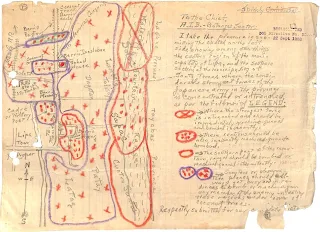
WWII Intelligence Map of North and East of Lipa Showing Japanese Positions
Below is an intelligence map submitted by the Lipa Guerrilla Regiment (Paran’s Unit) to the Allied Intelligence Bureau (AIB) showing Japanese positions and installations to the north and east of the then-town of Lipa in Batangas. The map is extracted from the files1 of the unit as submitted to the United States Army as part of the guerrilla unit’s application to gain official recognition as an element of the Philippine Army in the service of the Armed Forces of the United States during the liberation of the country.
Inside the map is the following text [edited by Batangas History, Culture and Folklore] provided by the map creator(s) with the necessary legend for using or interpreting the map:
“I take pleasure in submitting the sketch of the east side showing, among other things, the eastern region of the municipality of Lipa, and the southern section of the municipality of Santo Tomas, where the considerably strongest forces of the Japanese Army in the province are concentrated or entrenched, as per the following LEGEND:
“[Encircled with red crayon with ‘x’ in the middle] where the strongest force is entrenched and should be immediately machine-gunned and bombed incessantly.
“[Encircled with red crayon with multiple red dots inside] These sections should be also machine-gunned and bombed.
“[Encircled with red crayon] The southern part of the mountain range should be bombed or machine-gunned intermittently.
“[Encircled with purple crayon and red spots inside] Scouters or observation planes should always get busy and in readiness to bomb or machine-gun any member of the enemy [forces] infesting the regions under [the] cover of coconut trees.”
Click to download a high resolution copy of the map in PNG format.

