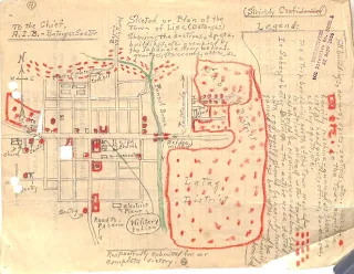
WWII Intelligence Map of Lipa City with Japanese Positions
Above is a map of what is now the City of Lipa submitted to the Allied Intelligence Bureau (AIB) by the Lipa Guerrilla Regiment Paran’s Unit. The map was titled by Paran’s Unit as “Sketch of Plan of the Town of Lipa (Batangas) showing the sections, spots, buildings, etc. occupied by the Japanese Army as headquarters, store rooms, offices, etc.” It has been extracted from the digitized files1 submitted by the guerrilla unit to the United States Army in its bid to gain recognition as an element of the Philippine Army in the service of the Armed Forces of the United States during the liberation of the Philippines from Japanese occupation.
These Japanese installations were marked with red crayons. According to the legend provided in the map, all areas with red spots and boxes should be “heavily machine-gunned as these are used as headquarters, offices, warehouses, sentry spots, etc.”
Meanwhile, the area north of the town market marked with dotted lines was “entirely mined with foxholes and should be machine-gunned and bombed.”
Finally, about the Latag and Sabang districts, the guerrillas’ recommendation was that these should be “heavily machine-gunned” and that “the buildings behind the church should be heavily bombed.”
Click to download a high resolution copy of the map in PNG format.

